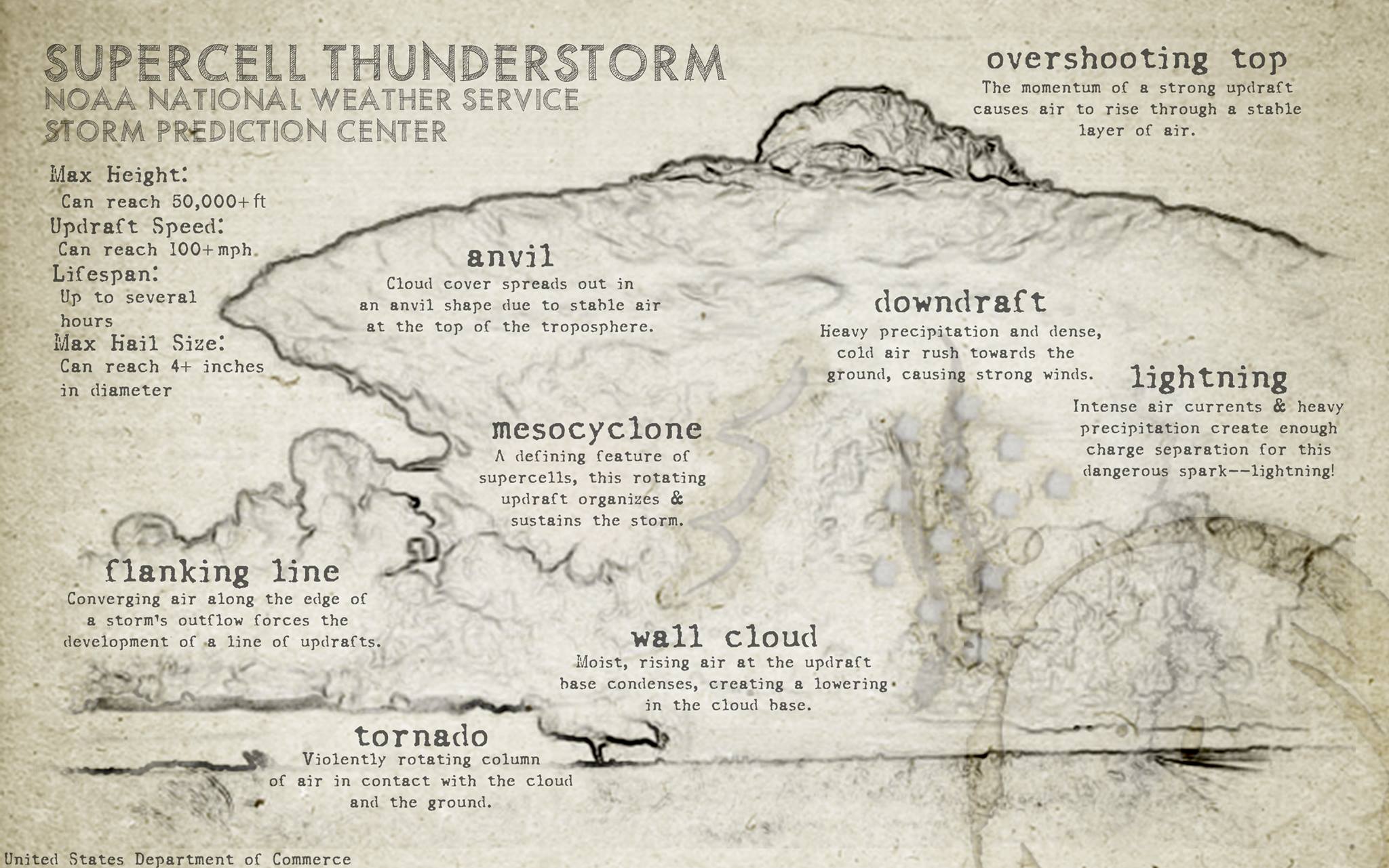
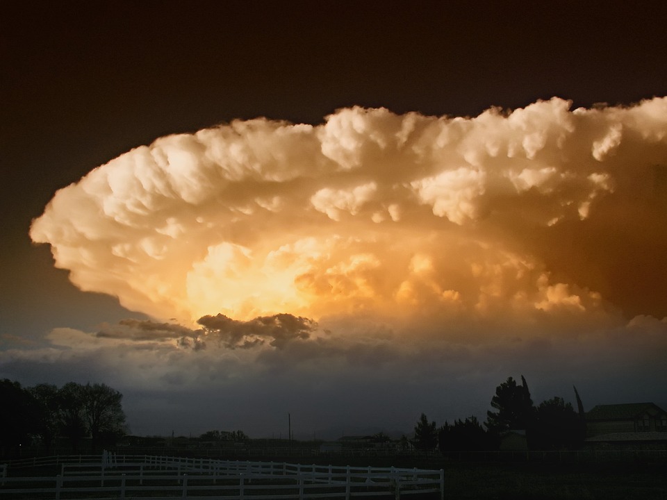
Severe thunderstorms and tornadoes have the potential to become incredibly violent and dangerous. Supercell thunderstorms – though the least common form of storms – are potentially the most violent. They can grow to massive sizes, pushing more than 50,000 feet into the air and into the troposphere. With 100+ mile per hour winds and huge hailstones, these systems and last for hours and inflict massive damage thanks to such severe conditions. Knowing how and why they form could make all the difference when it comes to avoiding violent thunderstorms.
What is a Supercell Thunderstorm?
Supercell thunderstorms are defined by the existence of a mesocyclone – a rotating updraft which organizes and sustains the storm. These sorts of severe storms can bring baseball-sized hail, damaging winds, and tornadoes to the immediate area of the storm. Supercell thunderstorms are made up of several different parts – at the most basic level, they feature a deep, rotating updraft and a strong downdraft.
An updraft occurs when warm, moist air rises and condenses within the storm. A downdraft is a column of air that rapidly sinks toward the ground. Downdrafts are usually accompanied by precipitation during a shower or thunderstorm. Thanks to a strong wind shear, the updraft and downdraft are usually in different places. This allows the storm to thrive because it is constantly being fueled by favorable conditions. Wind shear is the rate at which wind velocity changes from point to point in a given direction.
Below the storm cell, at the strongest point in the updraft, a wall cloud can often form. This is the point at which the supercell can become a much more devastating thunderstorm. When these wall clouds being to rotate, it indicates the potential for tornado formation and should be watched closely. Supercell thunderstorms are among the most favorable in which powerful tornadoes can form and thrive.
Different Types of Supercell Thunderstorms
There are three main types of supercell thunderstorms:
- Classic Supercells – commonly produce the most tornadoes; characterized by a strong downdraft with precipitation falling adjacent to the updraft.
- High-Precipitation Supercells – these storms are very strong and feature lots of precipitation. Tornadoes can be obscured by rain and can be difficult to spot; these supercells can look very imposing and severe and are accompanied by heavy rain and hail.
- Low-Precipitation Supercells – these types of storms are often big hail producers and can occasionally produce tornadoes. They are most common in the high plains of the United States and usually feature little precipitation and a spectacular looking storm cell.
How Does a Supercell Thunderstorm Form?
In order to form, all thunderstorms require moisture, instability and lift. Supercells, on the other hand, also require wind shear in order to form.
- Moisture – supercells require adequate moisture to be present in order to form.
- Instability and Lift – air that is warmer than the air around it tends to rise. Unstable air occurs when the air at the surface is warmed as cooler air remains above it. As the warmer air becomes unstable and rises, it forces cool air back down to the surface: creating instability and lift.
- Wind Shear – supercells must have a rotating updraft, which is accomplished through wind shear or when wind turns westward and speeds up as it rises. This wind shear creates horizontal momentum, which is then tilted upwards by a strong thunderstorm updraft, creating the deep, rotating updraft that supercells require.
Stay Alert and Informed
Smartphones and many other forms of communication have changed the way in which we are notified of and prepared for storms. Wireless Emergency Alerts (WEA) are emergency messages sent by authorized government alerting authorities through your mobile carrier. These alerts are automatically sent to all WEA-capable phones during an emergency. This service is sponsored by the National Weather Service, FEMA, the FCC, and the Department of Homeland Security. Many local and state public safety agencies also contribute resources toward the program. Alerts include extreme weather warnings, local emergencies, AMBER alerts, and Presidential Alerts during the time of a national emergency. You can visit here to learn more about Wireless Emergency Alerts and how they have saved lives.
While these alerts are a clear benefit, you won’t always be at home or near your phone when disaster strikes. Being knowledgeable and prepared can mean the difference between life and death in the event of a tornado or hurricane. While the security of a safe room or bunker is your best bet, knowing how to react correctly will give you a much better chance of surviving mother nature’s wrath.
Protection with US Safe Room
Violent thunderstorms and tornadoes are nothing to take lightly. If you’re at risk of falling in the path of severe weather, make the smart investment with a safe room or storm bunker from US Safe Room. Hand-made with heavy-duty materials right here in America, our safe rooms and storm bunkers are designed to shield you and your family from the devastating chaos of severe weather and disasters. With custom finishes and a selection of doors that feature a secure multi-point locking system, our structures are durable and versatile enough to fit all of your requirements. When you think of unmatched strength and quality in safe room construction, think US Safe Room.


